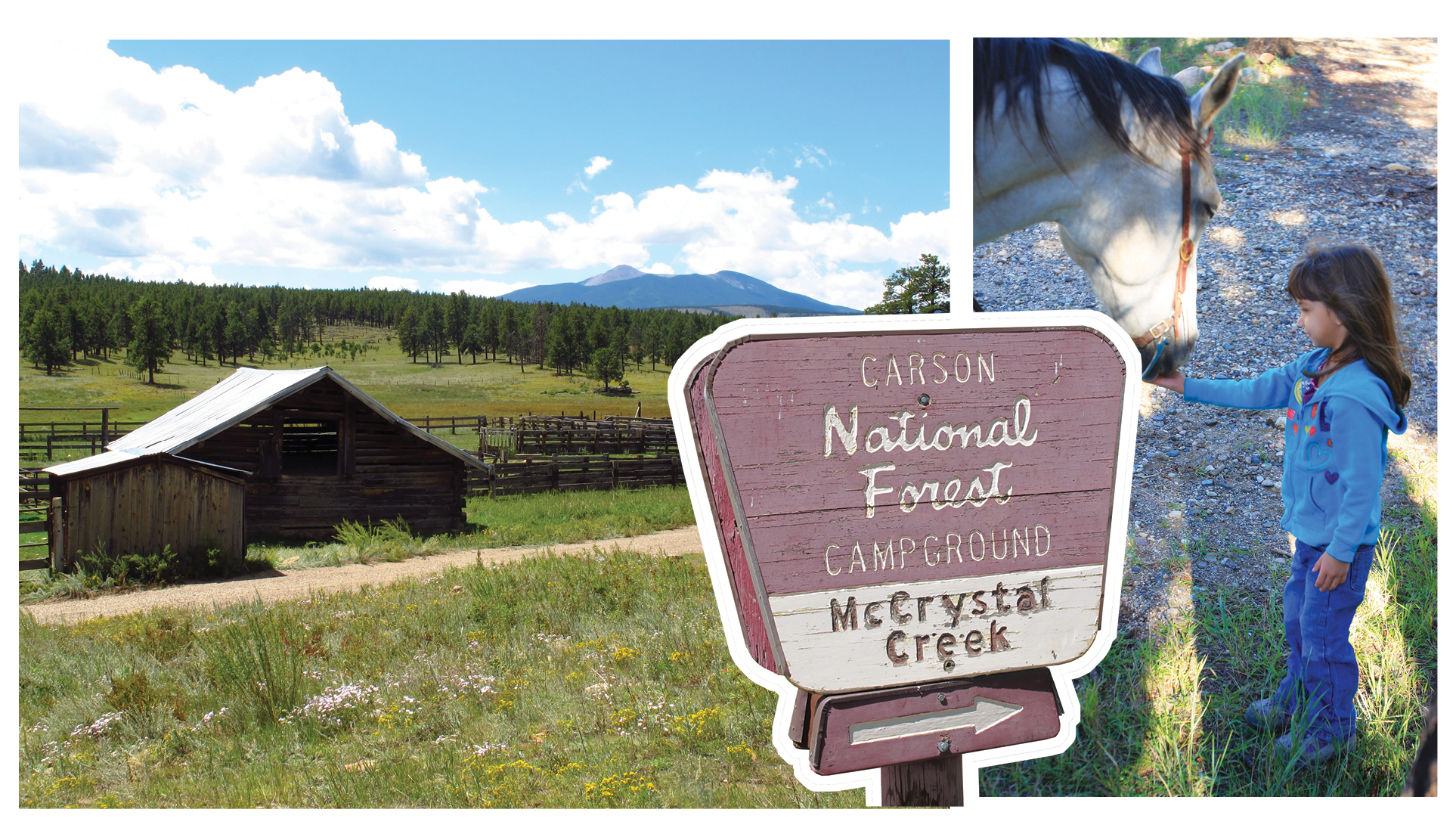
For awe-inspiring backcountry rides, plan now for a summer adventure in McCrystal Creek country, a treasure for trail riders in northern New Mexico’s stunning Sangre de Cristo Mountains, the southernmost subrange of the Rocky Mountains.
[RELATED: WHERE-TO-RIDE GUIDE]
On these mountain slopes, Carson National Forest offers equestrian adventurers 330 miles of trails on 1.5 million acres, 86,000 of which are a designated wilderness accessed only by trail riders and hikers. Elevation ranges from 6,000 feet to 13,161 feet atop Wheeler Peak, the highest point in New Mexico. Black bears, mountain lions, bobcats, elk, mule deer, antelope, bighorn sheep, eagles, hawks, and wild turkeys populate the area, as well as smaller mammals and songbirds.
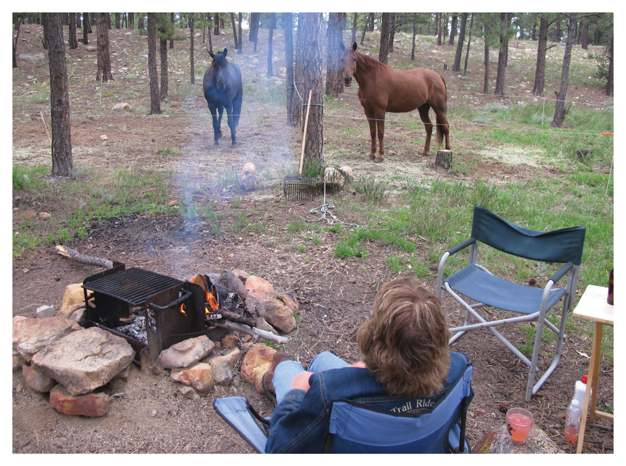
The area’s equestrian camp, McCrystal Campground, sits at 8,100 feet elevation in the heart of the national forest’s 100,000-acre Valle Vidal Wildlife Management Unit. Plan for a rustic camp—you’ll find water for your horse, feeders, corrals, tie racks, picnic tables, and fire rings, but there’s no potable water, electricity, or services.
We explored the trails here in the summertime aboard our Missouri Fox Trotter geldings, Nate and Cowboy. Here, we’ll share our from-the-saddle reports of rides we directly accessed from McCrystal Campground. Then we’ll give you a rundown on more rides in the area, plus an inside look at a historic hotel in Cimarron perfect for pampering yourself after your rugged adventures. Finally, we’ll tell you what you need to know before you go.
Getting There
To reach McCrystal Campground from Cimarron (about 2 hours northeast of Santa Fe), take US Route 64 east for 5 miles, then turn left (north) onto Cerrososo Rd. You’ll follow this gravel road for 21 miles to the boundary of the Valle Vidal Unit, then drive an additional 8 miles to the campground.
The gravel road to the campground is good in dry weather, but when it rains, it can be slippery and possibly impassable. We drove in after a rainfall and had to use four-wheel drive in a few spots to get our rig through.
However, the drive is beautiful, beginning in a canyon with pinyon pines and running through grassy valleys into ponderosa pine country. We watched wild turkeys strutting near the road, like a feathered parade. The campground is a welcome sight after driving nearly 30 long dirt miles!
Top Rides
After setting up camp with our living-quarters trailer, we were eager to explore the trails. Here’s a rundown of our top rides from McCrystal Campground.
North Ponil Creek-Seally Canyon Loop Ride. First, we rode to Ponil Park, a 12.5-mile loop ride that surpassed our expectations and left us with a tired glow after a day well spent on horseback. As late as 1910, Ponil Park was home to workers supplying the Cimarron & Northwestern Railroad. However, in 1921, the railroad track going into the mountains for timber was torn up and the little town of Ponil Park was abandoned.
We packed up lunch, strapped on rain gear (summer is monsoon season in New Mexico), and headed out of camp on a trail behind Unit #18. We followed McCrystal Creek eastward, staying on the left side and keeping an eye out for bogs. We soon came upon the remains of an old homestead.
Continuing southeast, we went through a gate, crossed the main road, and continued riding down the service road for the next 2 miles into a nonmotorized area. We rode through meadows sprinkled with flowers. Groves of leafy aspen trees shaded the banks of the North Ponil Creek as it meandered south.
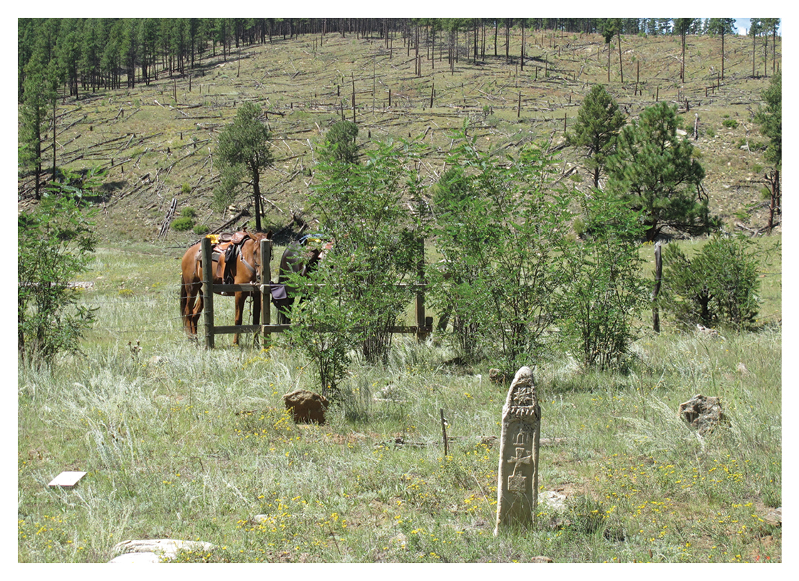
When we reached the remains of an old bridge, we crossed the creek and explored a desolate 1880s-era cemetery. Three stone markers still stand; one is for a 19-year-old woman, and another is for a 23-year-old man. Old, forgotten cemeteries inevitably cast a pensive spell on us. We wonder about the folks buried there, what their lives were like, and why they died so young.
Here, among relics and tatters of past history, the riding is easy, and the rides are surrounded by nature’s beauty. If you’re like us, you’ll reflect on the lives of those who came before us as you ride past bits and flotsam of their lives, scar the landscape with rusty iron implements, decaying wood, and crumpling rock piles.
After exploring homestead ruins, we continued down the trail until it split. We turned right (west) to go up Seally Canyon, which continues about 4 miles. There, we found Seally Canyon Cemetery, more signs of old homesteads, and the remains of an old sawmill.
An interesting note about Seally Canyon Cemetery: our camp host found his great-grandfather’s headstone lying down amid a tangle of weeds. He knew his great-grandfather had worked for the railroad in Ponil Park but had never expected to find his gravesite.
Near the end of the canyon, we arrived at an open gate that led us into a vast meadow with a lake on our right. As luck would have it, we got caught in a drenching shower. As we gaited across the meadow, stabs of lightning spurred us forward. Soaked, we found shelter in the trees and laughed at our impromptu adventure over hot coffee and hearty sandwiches.
After lunch, we veered right and rode to another open gate. Here, the old Ring Ranch comes into view, but go straight across the meadow with the fence on your right until you come to another open gate. Go straight to the Ring Ranch—there’s a trail and interpretive signs. (You’ll be less than a mile from camp.) The Ring Ranch offers a glimpse into what farm life was like in the late 1800s and early 1900s.
A big claim to fame for the Ring Ranch was its inhabitants: Tim Ring and his wife, Catherine, had seven daughters!
McCrystal Ranch Ride. This was another easy ride out of camp. This ride will take you to the homestead of John McCrystal, one of the leaders of the Colfax County War in the 1880s and for whom the campground is named. McCrystal and others had built their homes on the Maxwell Land Grant believing it would become public domain. When it didn’t, a bitter battle ensued; Maxwell Land Grant won. In 1890, McCrystal was forced to pay 960 dollars for 320 acres.
Begin by taking the old Forest Service road behind Unit 44, and ride down to McCrystal Creek. Turn left, and follow the creek north. We followed the creek the entire way to McCrystal’s old homestead, roughly 3.5 miles. The creek winds though meadows tie-dyed with a profusion of wildflowers.
In the distance to our left, Little Costilla Peak towered 12,584 feet above sea level. At the meadow’s edge, close to 50 wild turkeys raced under ponderosa pines.
When you’re about 2.3 miles from camp, the trail will come very close to the fence. Go up and around to the right, then back down into the meadow. The trail fades out; just continue following the creek. As you gain elevation, you’ll notice mighty blue spruce replacing aspen groves.
When you’re about 3.5 miles from camp, the old McCrystal place comes into view. John McCrystal and his wife, Annie, had six children; we wondered if they socialized with the Ring family and their seven girls. Today, there isn’t a lot left of the old homestead. Axe marks can still be seen on faded-gray logs; some logs are dovetailed together. The skeleton of an old wagon sits behind where the house once stood.
We ate our lunch by the old homestead, then continued riding north on the left side of the creek. We passed a lone stone chimney with an animal skull inside. Eventually, the trail led us into a series of hidden valleys surrounded by ponderosa pines and remnants of the rugged folks who lived in the area long ago. After we finished exploring, we backtracked our way to camp for refreshments. Overall, our ride was 10.3 miles, with a gain of 800 feet elevation on our way out.
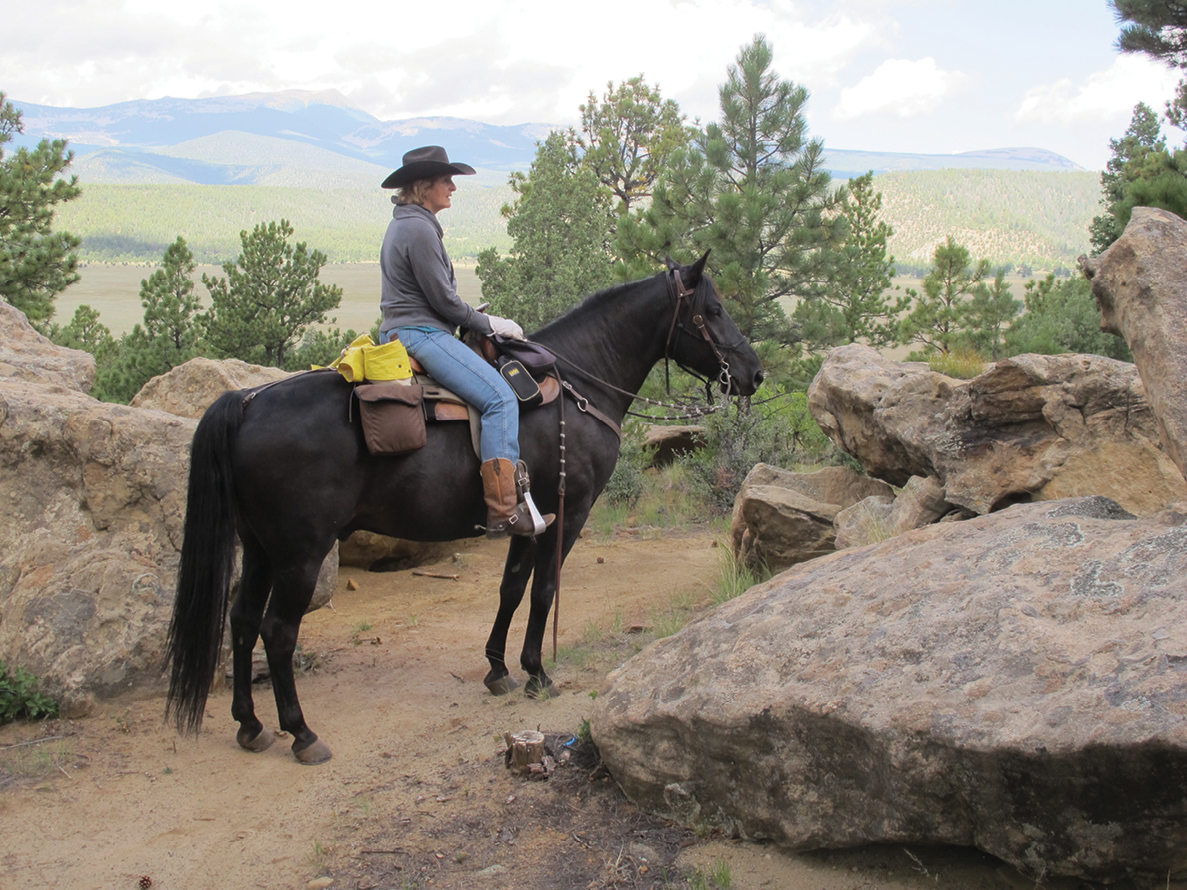
Whitman Vega Ride. We began this ride as if we were riding to Ponil Park, but when we reached the Forest Service road after the old chimneys, we went left (north) instead of right (south). We followed a soft-dirt, two-track trail and came upon a Boy Scout camp. The Scouts’ trail was a fun gaiting trail for our Fox Trotters! The trail led out of a valley and up a ridge where it wound around giant boulders. We ate lunch by a large flat rock with lovely valley views and warm sunshine. This entire area is a safe, relaxing place to ride with interesting artifacts.
Campfire Chat
At McCrystal Campground, we met vivacious horse folks. Pam and Danny Horne from Athens, Georgia, and their friends, Tommy and Sherry Nash from Munroe, Georgia, had trailered in to enjoy the backcountry setting of New Mexico. They told us they loved the openness of the area and the fact that they could ride in any direction. They also enjoyed the history of the region and lack of undergrowth. Pam missed electricity, but she said that the dry air and the area’s natural beauty more than made up for the rustic conditions. Sherry especially enjoyed poking around the cemetery.
After being here for five days, the friends enthusiastically shared their impressions of the area. They saw elk, deer, turkey, and a badger. Tommy Nash summed it up nicely when he exclaimed, “It’s as close as you can get to riding on the Ponderosa Ranch in [the television show] ‘Bonanza’!”
More McCrystal Rides
Here are more recommended rides in McCrystal Creek country.
Clayton Corral Loop Ride. From McCrystal Creek Campground, drive west on the Forest Service road for about 9 miles to Clayton Corral. From this point, you can do a loop that does involve some road riding. For about a 9.5-mile loop, ride south from the corrals to Vidal Creek. Follow the creek west between two small cliffs to Clayton Camp, an old cow camp. From here, follow the tracks of an old road that runs north along Comanche Creek. In about 2 miles, you’ll reach a parking area at the main Forest Service road. Follow this east about 3.75 miles back to Clayton Corral.
La Belle Lodge Loop Ride. This is an almost-7-mile ride. Start from the same point where you came out to the parking space on the Forest Service road on the Clayton Corral ride. Start south, and retrace your route along Comanche Creek back to Clayton Camp. From the camp, steer right along Comanche Creek. After crossing the stream, you’ll come around the corner of a grassy knoll; look for a faint intersection. The more defined trail goes left into a marshy area; follow the fainter road, which heads to the right, goes up a small drainage to a ridge, and eventually passes through a gate. You’ll come to the abandoned La Belle Lodge, at one time a thriving gold mining town. From here, you can follow La Belle Creek down to Comanche Creek and go left back to the trailhead. Or, you can continue following the faint road, which crosses a ridge, drops down to Gold Creek, and emerges across the road from the trailhead you started from.
Powderhouse Canyon Ride. From the parking area for the La Belle Lodge Loop Ride, drive west for about 4 or 5 miles until you reach Forest Road 1900. Turn right, and drive about 2.6 miles to a parking area. From here, ride up the old logging road, following it north along the creek. After about .75 miles, turn right on a faint road, and cross the creek. Here, the old road follows a fence line as it curves back to the southeast and heads up Powderhouse Canyon. Old logging roads branch off the main route, which makes for interesting riding. The main route stays close to Powderhouse Creek. Watch for beautiful views of aspen groves and Little Costilla Peak in the distance.