The Sierra Nevada Mountains reclined before us in a south-to-north line of jagged, snow-dipped majestic peaks. This great mountain range, home to several wilderness areas and national forests, provides a spectacular mountain playground for trail riders.
Our exploration would take place between the towns of Bodie, California, to the south and Markleeville, California, to the north. We had our trusty mounts, Buddy and Scout, both Missouri Fox Trotter geldings. In addition, we had time, maps, and great weather. Adventure was in the air!
A Grand Ghost Town
By the 1850s and 1860s, a number of boomtowns had developed in the eastern Sierras. The grandest of them all was Bodie. Today, Bodie is preserved as a state historic park and is probably one of the best ghost towns in America. It’s well worth seeing. In addition, you can ride your horse through town! This was something Buddy and Scout were chomping at the bit to do.
Bodie is located seven miles south of Bridgeport, California, and 13 miles east of Highway 395. The town sprung up after a gold strike in 1859. By 1879, Bodie boasted a population of around 10,000 and had roughly 2,000 buildings. More than 60 saloons and dance halls lined the streets, providing entertainment for miners after a hard day’s work.
Bodie was known as one of the most lawless, wildest, and toughest mining camps in the West. Killings occurred with monotonous regularity and were almost daily events. In 1881, Reverend F. M. Warrington described Bodie as a “sea of sin, lashed by the tempests of lust and passion.”
As a state historic park, Bodie is preserved in a state of “arrested decay.” A good place to start your exploration is at the museum and visitor center. Here, you can get maps of the town, see historic displays, and purchase tickets for the Standard Mining Company Mill tour.
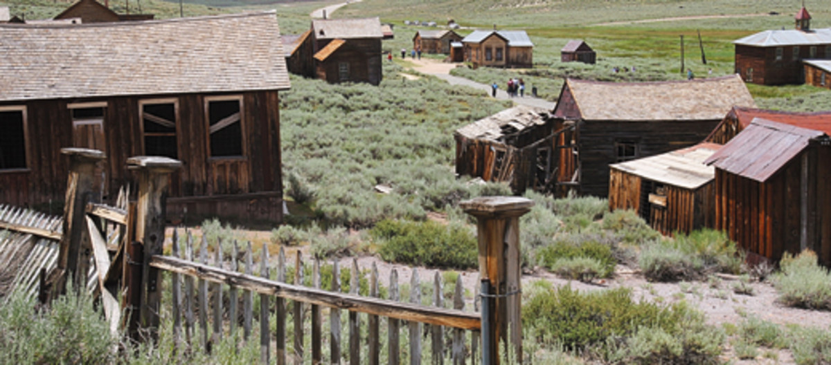
After scouting out the town, we saddled up Buddy and Scout. Riding into town, up dusty streets, and past long silent buildings gave us a feeling for what it was like to be back in the 1870s. Outhouses lean at crazy angles, slanted steps lead to houses with tilted doors hanging by rusty hinges, and weathered wagon bones lie scattered in the sagebrush.
On the way out of town, we paused to study the door of a lonely bank vault. The bank had been robbed in 1916; the thieves escaped with $4,000. In 1932, the bank burned, leaving only the door and portions of the vault.
An Enchanting Canyon
Buckeye Canyon is an enchanting place to ride that captures the essence and feeling of the Sierras. To find the trailhead, take U.S. Forest Service Road 017, located about 3.5 miles west of Bridgeport on Highway 395. Follow this road for approximately six or seven miles to the trailhead.
Although space is limited, we had no trouble finding a parking spot. At the trailhead, there’s a private corral available for the public to rent. To rent the corral, call the Hunewill Ranch (760/932-7710).
The trail up Buckeye Canyon is fairly level. It follows a glacially scoured valley with verdant meadows and trees, and is surrounded by snowcapped peaks.
The first couple of miles follow an old logging road that’s intermittently squeezed between lodge pole pines and then set free in undulating meadows. Be sure to ride at least to Big Meadow, about five miles up the trail.
Big Meadow is a charming two-mile long grassland surrounded by lofty peaks. This meadow wasn’t always so peaceful. Around 1879, the meadow resounded with sounds of axes and the whirring of a sawmill blade. The sawmill provided lumber for the growing town of Bodie, located nearly 30 miles away. Ox carts pulled by 16 oxen laboriously transported lumber to Bodie.
Disappearing Trails
Because of limited space, we didn’t spend a night at Buckeye Canyon. Instead we drove to Burt Canyon for camp. The turnoff for this trailhead is U.S. Forest Service Road 990, located approximately 16 miles west of Bridgeport on Highway 395. From the junction, travel about four miles south to the trailhead.
There are two places to horse camp. One is located in a flat across the road from the entrance to Obsidian Campground. The other is about a quarter-mile farther, just before the road crosses a bridge over a stream exiting from Burt Canyon. We selected the latter camp, because it had plenty of room to turn around and space for an electric corral.
From this camp, you can access two trails: Burt Canyon and Molybdenite Creek. In addition, you can ride and explore the road beyond camp.
We began by riding up Burt Canyon. Notice the large juniper trees near the start of the ride. These were some of the largest junipers we’ve ever seen, with trunks six feet across at the base. Many of the trunks were exceedingly large for their height, and featured splintered tops and thick limbs that were grotesquely twisted.
Follow an old road for the first two miles past a few summer homes. About 1.5 miles past the end of the road, the trail enters the 47,000 acre Hoover Wilderness. This looked like a beautiful and inviting valley; however, we were unable to proceed because early summer snow melt and rains blocked this portion of the trail.
We decided to attempt crossing the ridge between Burt Canyon and Molybdenite Creek. The U.S. Forest Service map shows a cross-cut trail that goes by a place called Rickey’s cabin. Earlier, we’d asked the locals about Rickey. It seems Rickey was a famous sheepherder of yore. He also lent his name to the 10,126 foot Rickey’s Peak, located to the east.
One person didn’t think the cabin was still standing; another thought it was. There’s no marked trail junction. About a mile up after leaving camp, look for a place where the road veers right and there appears to be a gash going uphill on the left.
We discovered that the trail on the map no longer exists. We rode uphill following portions of a trail and any open areas that went in an easterly direction. What little trail we had soon disappeared.
Occasionally, we found small rock cairns; we kept riding. Even if we missed the cabin, we hoped to ride cross country to Molybdenite Creek and follow it down to camp, thus completing a loop.
Surprising Discoveries
We expected to find the cabin at the top of the ridge, but instead found solitude and vast views of majestic wilderness. After descending the eastern side of the ridge, we rode into a stand of pines and discovered the largest Jeffrey pine we have ever seen. It must’ve been five or six feet in diameter and more than 100 feet high. The area around it felt like a spiritual place.
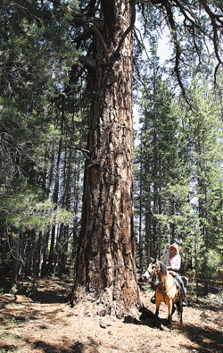
The Jeffrey pine, also called the vanilla-bark pine, is the predominant pine of the eastern Sierras. It’s similar to the Ponderosa pine, but is much larger, has larger cones, and possesses a distinct vanilla or pineapple odor. To tell the difference between a Jeffrey and Ponderosa, hold the cone. If the cone feels prickly, it is a Ponderosa; if the cone feels smooth, it’s a Jeffrey.
Near the Jeffrey pine was a smaller tree with bear-claw scratch marks. Buddy eyed the marks with nervous anxiety. But as soon as he realized these were black bear marks and not the marks of grizzlies he was accustomed to in the Northern Rockies, he relaxed.
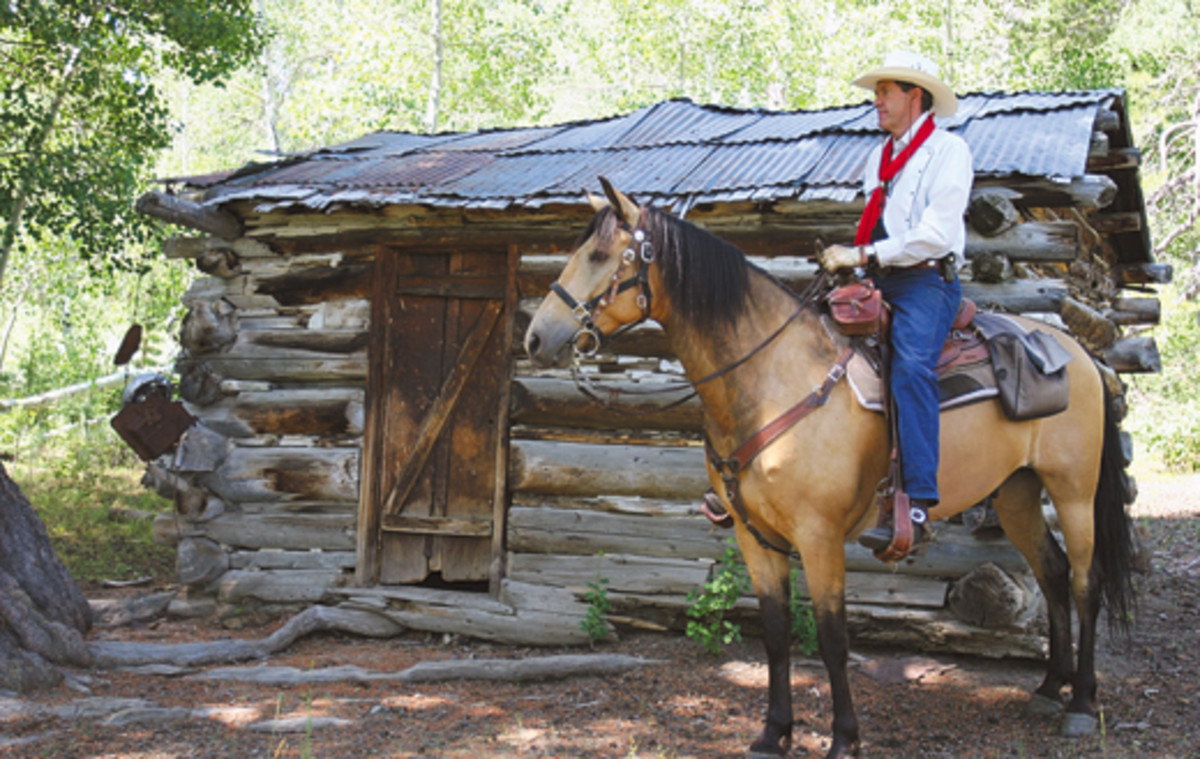
Reluctantly, we gave up hope of finding Rickey’s cabin and started riding downhill, working our way to Molybdenite Creek. But, as often happens, success was around the corner. We rode into an open glade, and there was Rickey’s cabin!
Placed in a grove of gigantic Jeffrey pines, the cabin appeared to be in a little fairyland. We almost expected to see the Seven Dwarfs come marching out, singing “Hi Ho! Hi Ho!” At some point in the ramshackle cabin’s history, someone had installed a metal roof, which saved it from the ravages of time.
After exploring the little cabin and its surroundings, we rode through an open meadow and down into the valley of Molybdenite Creek. If you have time, you can ride up the creek towards McMillan Lake or go cross country to Long Valley Ponds.
Since we were short on time, we rode a little over a mile to Obsidian Campground, then back up the road to where we started. Even if you don’t find Rickey’s cabin, this is still a worthwhile loop for its scenic beauty, cross-country ramblings, and opportunities for additional rides.
A Place of Contrasts
Our next ride was from Leavitt Meadows up the West Walker River canyon. From Burt Canyon, return to the highway, and travel one mile west to Sonora Junction. At the junction, turn west on Highway 108, and drive about eight miles to Leavitt Meadows trailhead. Caution! Do not approach this from the west. There’s a 26 percent grade that could cause serious trouble for rigs with horse trailers.
We parked at the second parking lot on the right. From there, we rode our horses across the highway and followed signs that took us around private property to the West Walker River. Be careful crossing the river in early season. Glaciers in the high country melt on hot summer days, causing the river to rise by late afternoon. We discovered this on our return crossing; the water was over our boot tops!
Riding up the West Walker River introduces you to the contrasts of this country. Here, the dark rock thrown up by volcanoes meets the lighter, more typical batholithic granite. This was one of our favorite rides. The wide valley of Leavitt Meadows gives way to the river canyon that was interspersed with pine, aspens, and grassy parks.
We rode to a sign that explained this trail was used by emigrant wagon trains long ago. It was difficult to imagine a wagon train working its way over and around all these rocks toward Emigrant Pass far to the south.
About three miles into the ride, we came upon a pleasant surprise of two small lakes situated next to each other. Roosevelt Lake was the first lake and is home to brook trout. The second lake is Lane Lake. There’s a nice picnic spot on the south shore of this lake. Look around the rocks near the shoreline; you’ll see silent, skittering crowds of crawfish.
The trail continues pleasantly up the canyon past tiny Hidden Lake to Fremont Lake, which is about nine miles from the starting point. Our time in the Leavitt Canyon country was coming to an end. We fox-trotted and hurried down the trail to get back before dark. As we neared the end of our ride, we were treated to a sunset with a rich spectrum of colors.
A Beautiful Loop
Wolf Creek Meadows has a horse camp and two rides that provide a great introduction to the Carson-Iceberg Wilderness Area. To find the trailhead, return to Sonora Junction, travel north on Highway 395, and turn left on Highway 89. After 18 miles on Highway 89, turn left on Highway 4. Go about 2.5 miles, and turn left on Wolf Creek Road. Follow this dirt road about 3.3 miles to a left fork where you turn and descend to the north end of Wolf Creek Meadows.
The north end of Wolf Creek Meadows is a very pretty spot providing a nice place to camp with a scenic view across the valley. From here, you can access the High Trail that makes an approximate 15-mile loop returning via the East Carson River Trail.
It’s not often in a day ride that we’re able to ride loop trails. We were eager to go. We saddled Buddy and Scout, tucked a yummy pack lunch in the saddlebags, and rode about a quarter mile to the trailhead.
Electing to start on the High Trail first, we rode out with brief views back to Wolf Creek Meadows. The trail rose steeply, gaining about 1,500 feet in elevation until it crested and paralleled Silver King Valley below. Here, there are great views to the valley and to the Freel Peaks area to the northwest, beyond whose summits lies Lake Tahoe.
After about 6.5 miles, we made a sharp descent into the East Carson River valley. The Carson-Iceberg Wilderness map shows the trail crossing the river. However, don’t cross. Instead, turn left, and ride north about one mile along a lush river bottom until the trail turns left for the return trip. Along the river valley are numerous, idyllic picnic spots.
We followed the East Carson River trail back to our starting point. The trail follows the river valley, traveling through timberland sprinkled with juniper, Jeffrey pine, and white fir. It entered a canyon where we marveled at volcanic rock formations that abound in the area.
Near the end of our route, we rode past the shallow Wolf Creek Lake, then climbed west up the base of steep volcanic slopes to a ridge above the lake. From here, we made a quick descent to complete a beautiful loop in the backcountry.
Ah, Wilderness
Another, larger horse camp is located at the south end of Wolf Creek Meadows about two miles farther down the road. From here, you can travel up Wolf Creek and access the center of the 160,000-acre Carson-Iceberg Wilderness.
This horse camp is spacious, shaded by a large group of pines, and situated next to Wolf Creek. However, it had been sadly misused by thoughtless riders. We saw rotten hay piles, manure piles, and broken beer bottles everywhere.
To keep horses welcome, hay should be raked up and packed out. Trash should be collected. Horse manure should be removed or scattered for more thorough decomposition. It’s easy to imagine how a non-horseman, seeing a mess like this, would campaign against horse use on public lands.
The trail up Wolf Creek begins by going past interesting bluff formations, through open meadows, and then enters a wooded stretch for several miles. About 3.5 miles up the trail, we came to a severely washed-out section, but blue ribbons led us on a detour around this section.
We rode six or seven miles up the trail and came into more beautiful open areas. We noticed a tree that had been struck recently by lightning, testifying to the sheer force of nature. This trail divides into several other trails and eventually leads to the Pacific Crest Trail. Anyone’s wilderness quota can be happily met in this country.
Ranch Relaxation
We’d been traveling for a month with Buddy and Scout; we continue to be amazed at how easy it is to travel with horses. They never beg, whine, or ask, “Are we there yet?” However, once in a while, we enjoy taking a break from traveling. Our next stop was one such place.
Nestled in a small valley just north of Virginia City, Nevada, is the Seven Mile Canyon Guest Ranch, also a bed-and-barn. Guests are allowed to bring their horses to the ranch where spacious barn stalls and turnouts are provided.
For lodging, there are several cabins from which to choose. Each cabin has a fireplace and satellite television. Some have hot tubs and kitchenettes. Breakfast (included) is delivered each morning to your cabin in a basket. Relax in the hot tub while watching a western sunset and wild mustangs grazing along the ranch perimeter.
The ranch owners are more than happy to give you ideas on where to ride. Some folks even ride from the ranch into old historic Virginia City. This is more safely done in the evening when tourist traffic has significantly decreased.
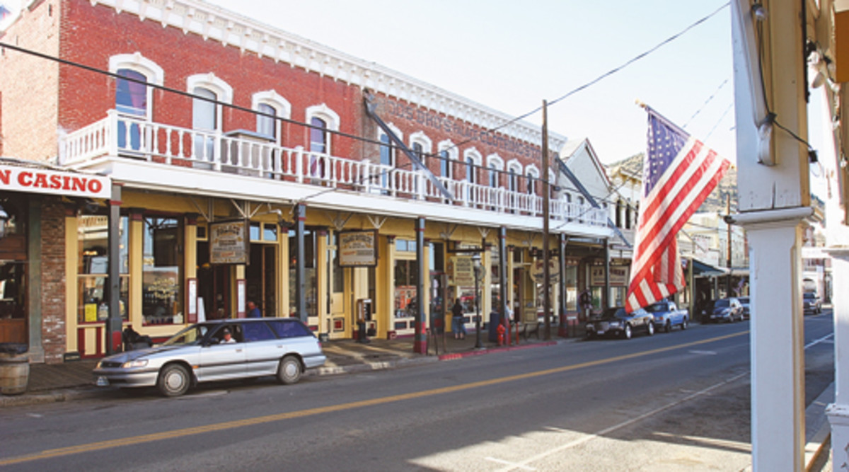
Virginia City is a great place to visit. This was the site of the historic Comstock Lode, one of the greatest silver strikes in history. The wealth from these mines helped finance the Union during the Civil War, helped build transcontinental railroads, and even helped build San Francisco in the 1860s and 1870s. Today, the historic buildings and attractions wait for visitors to explore.
After a few days rest, we loaded up Buddy and Scout and headed home. Being with our horses in this magnificent land provided us with precious moments in time that we’ll always remember. The silent beauty of the Sierra Nevada Mountains, the brilliant ribbons of rivers, and the adventurous trails are ready to be explored.