Southwestern Utah is a land of unique diversity. Here, you can ride in desert canyons painted amber, rose, and orange, then head into mountain forests, laced with cool streams and fringed with peaks rising to 10,000 feet in elevation.
You can ride in high and low desert areas, through slot canyons and redrock formations, and into the Pine Valley Mountain Wilderness.
It’s a year-round equestrian Utopia!
We visited with Freddy Dunn, an avid rider and member of the local chapter of the Back Country Horsemen of America. Freddy told us that the area around St. George is especially interesting for riders because of the varying landscape.
More than 75 percent of the local county is public land, comprised of Bureau of Land Management land, state parks, and the Dixie National Forest. These public lands are preserved for all of us to treasure and enjoy.
“We try to keep hoofprints on as much of it as possible,” Freddy told us.
Colorful Valley
We didn’t need much encouragement to visit this area. Our good friends, Mike and Kathy Duvall, live near St. George.
When they invited us to stop by, our horses ran for the trailer!
Mike and Kathy live in Dammeron Valley, about 11 miles northwest of St. George. Dammeron Valley is a planned, tidy community with home sites that welcome horses. Locals can ride out of their backyards onto trails that weave throughout the surrounding forests and canyons.
We enjoyed a beautiful ride from Mike and Kathy’s home. You can access this same ride from the Red Mountain Trailhead, located on State Highway 18 as you travel northwest from St. George. Just after Milepost 15, enter the parking lot on the left.
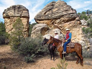
Don’t take the trail on the right by the sign; it becomes rough and rocky. Instead, ride out of the south end of the parking lot, through a walk-through gate (which is by a green gate). When the trail forks, bear to the right. We rode our Missouri Fox Trotter geldings, Cowboy and Nate. Mike rode his Fox Trotter, Sunny, and Kathy a Tennessee Walking Horse, Indy.
Accompanying us were the Duvalls’ friends, Steve and Carol Stowers. Steve rode his Quarter Horse, Shadow, and Carol rode one of the Duvalls’ Fox Trotters, Brumby.
Carol Stowers hadn’t been on a trail ride for 30 years; we hoped it would be a great one!
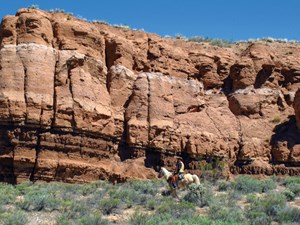
From Duvall’s home, we rode into the Red Mountain Wilderness to our first destination, Snow Canyon Overlook. Working our way southeast, we rode by multicolored rock formations and a bounty of plant life: junipers; beavertail cacti; scrub oak; and manzanita.
After riding through numerous washes and across rocks, we finally came to an overlook. And what an overlook it was! Snow Canyon stretched out in gorgeous panorama hundreds of feet below. This is a delightful place to pause for lunch and soak up nature’s handiwork.
Long ago, rocks in this area were sand dunes. The sand was whipped by wind and water into fantastic shapes; time cemented them into stone.
Interspersed in these sedimentary rocks are igneous rocks from ancient lava flows. The result is a visual delight of random colors: white; cream; tan; pink; orange; red; and gray. The sunny afternoon provided us with interplays of light and shadows, colors dancing on stones.
Snow Canyon was first discovered by Mormon settlers looking for lost cattle in the 1850s. Later, it was discovered by Hollywood. This setting was used in such movies as Butch Cassidy and the Sundance Kid, The Electric Horseman, and Jeremiah Johnson.
On our return trip, Mike led us crosscountry through washes, gullies, and hills.
Along the way, Mike and Kathy generously shared with us their secret hideaway. It was a hidden alcove made up of a rock wall on one side and a sandstone-shaped amphitheater on the other. In this sheltered spot, the Duvalls have had cozy campfires and tasty picnics.
Our concern for Carol quickly evaporated. As we watched Carol riding cross-country and doing short lopes, we noticed she had a breathless grin, her face wreathed in a smile.
Relaxing River Ride
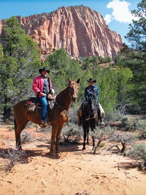
It was our good fortune to meet and ride with Paul Sloane, president of the southwest chapter of the Backcountry Horsemen of Utah. Paul led the Duvalls, Kristie Bennion, and us on a ride up the Santa Clara River. Paul rode his Fox Trotter, Ty. Kristie rode her Arabian Horse, Legacy.
To find the trailhead, go just past St. George. Turn left off Highway 18 onto the highway to Santa Clara. Just after Santa Clara, turn left on a road marked Tukupetski Trailhead. A half-mile later, you’ll arrive at the trailhead.
With lunches in tow and cameras readied, we rode from the parking lot and took the left-hand trail. The trail winds around a hill for a short distance before dropping down to a dirt road.
We turned right, and a short while later, we ventured into Santa Clara River Canyon. After riding through a gate, the real riding adventure and beauty began.
Listening to the rhythmic plodding of our horses’ hooves, we rode through the canyon, awestruck by nature’s beauty. Rock walls festooned with blooming cacti loomed on our right. The lazy Santa Clara River flowed on our left, caressed with cottonwood trees.
We followed the easy trail along the river until we came to huge boulders. It looked as though someone plucked them and placed them there for our inspection. The boulders are dotted with petroglyphs, markings from an ancient civilization.
Backtracking a short distance, we crossed the shallow river shaded with cottonwoods and turned to the right. From there, we did our own big, cross-country ride through badlands and semi-arid country punctuated with small scrub bushes. The Duvalls called the ride’s diversity “enchanting.”
Into the Mountains
Leaving deserts and rock canyons, we next traveled a short distance to the Pine Valley Recreation Area. Here, forest covered mountains rise thousands of feet above the valley floor.
To reach the trailhead, continue northwest on Highway 18 to the town of Central. Turn right on Forest Rd. 035. Drive about 11 miles to the Pine Valley Equestrian Campground.
This campground, situated at 6,800 feet elevation, is snuggled in a valley and surrounded by verdant mountains that stretch upward to 10,400 feet. There are 16 campsites. Most have corrals, a fire ring, and a picnic table.
Several rides originate from camp. We decided to do a loop ride that would circle the valley. To do this ride, we rode north, across the road and over to the Gardner Peak Trailhead. Then we rode three-quarters of a mile uphill to a signed junction and turned right.
At this point, we were on the Pine Valley Canal Trail. It really was a canal at one time, but when it was built in the early 1900s, there just wasn’t enough water to satisfy demand.
Today, riders can enjoy a pleasant, level ride and see sweeping views of mountains rising across the valley. Some thoughtful soul installed a bench and hitching rails so equestrians can tie up their horses and enjoy a picnic lunch.
On our ride along the canal, we encountered six wild turkeys and a group of mule deer.
The canal trail ends in a campground. To continue the loop, we rode south across the parking lot to a bridge over a creek.
From here, we rode a short way south cross-country to a paved road and followed it a short distance to the left to the Whipple Valley Trailhead.
From this trailhead, we turned right and followed Equestrian Trail #31036, riding west back toward our starting point.
We were riding on the south side of the valley with views to the north. We passed the Brown’s Point Trail, which offers a more rigorous outing. After about eight miles, we completed the loop by returning to the equestrian campground.
Zion National Park
No trip to southwestern Utah would be complete without a ride through Zion National Park, known for its stunning canyons and breathtaking scenery.
For folks without horses, there’s a horse concession located a few miles north of the park’s south entrance. If you’re there with your own horse, we recommend riding to Kolob Arch.
To get there from St. George, go north on Interstate 15. Take Exit 40, and go
to the visitor center to register. The park service allows up to 12 heartbeats in a group counting all horses and riders.
Drive past the visitor center on the Kolob Canyons Rd., and watch for the Lee Pass Trailhead on the left at the top of the hill.
Drive past this trailhead, and note the turnouts on the left side of the road. You must travel a short distance more to the end of the road where you can make a Uturn, then park in one of the turnouts noted earlier.
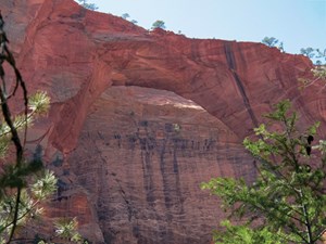
The ride to Kolob Arch is considered one of the most beautiful rides in Utah. From the Lee Pass Trailhead, we dropped about 900 feet into two different canyons. The trail was mostly in good shape, easy to follow, and had a number of stream crossings.
Our route took us down into Timber Creek, then left up La Verkin Creek Canyon. We were treated to views of towering red-and-white canyon walls and rock formations. Juniper trees and cottonwoods dotted the canyon floor. Mule deer darted in the shadows.
We met a number of backpackers on the trail. It’s a good idea for your horse to be accustomed to hikers with towering backpacks. After 6.6 miles, we came to a hitching rail. We left our horses there and hiked the last half-mile to the arch. This last portion of the trail isn’t suitable for horses and requires some athletic scrambling over boulders. It can be a real challenge in boots and spurs!
Kolob Arch is difficult to see, because it’s high up and against a wall of rock. However, it’s one of nature’s masterpieces. It’s the second-largest rock arch in the world, about the length of a football field.
Our horses happily headed back to the trailer, barely keeping ahead of a spring storm that dropped several inches of pelting snow.
Our trip to southwestern Utah was complete.
Kent and Charlene Krone combine their interest in photojournalism with a passion for horses. They’ve sold photographs to magazines, books, calendars, postcards, and video producers for more than 20 years. (For a sampling, visit www.superstock.com, and type “supplier:1314” in the search box.) They enjoy sharing their horseback adventures in the United States and Western Canada. Reach them at kentandcharlene@gmail.com